 Over recent months, I have been using ViewRanger GPS on my Nokia E71 mobile phone whilst out cycling. Here’s my review and a few tips for using ViewRanger based on my experiences so far.
Firstly, I’m not an expert user and I have used some of ViewRanger’s functions but not all. So, this is a first review and I will not cover every single aspect of the software. Just the bits that I have used. There are some features, like route navigation, that I have not used because my main usage is cycling and tracking/mapping the rides as I go, rather than following a specific route.
What is ViewRanger?
Simply put, it’s software that uses GPS to track your position and display it on a map on a mobile phone or other device (for example, an iPad). It works with a variety of different phones including Nokia (Symbian), Android-based phones (such as HTC), and iPhone. The software enables you to use an extensive range of route tracking and location-based functions, for example tracking your position and sending it via a system called Buddy Beacon so that others can see where you are. The software allows you to download and display maps on demand, some of which are free, and some (like Ordnance Survey maps) that you pay for.
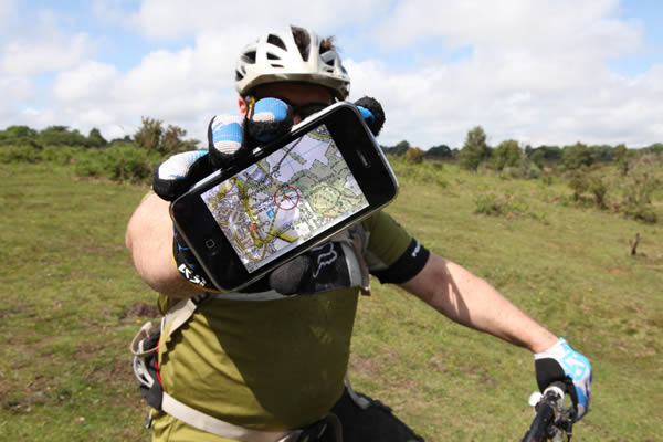
You can use ViewRanger to track, follow a route as you ride, or use it to send the route to a web-based application or service (more about that another time). Tracks can be stored and exported as GPX files which can subsequently be imported into other mapping services like Google maps. There’s a lot more that ViewRanger can do as well.
- ViewRanger features as described on the ViewRanger website.
The software can be purchased for £14.99 (iPhone) or £4 (Nokia store) and via several other retail and online stores. You need to activate the software after buying it and a username and password need to be entered.
Smartphone Required
Of course you need a GPS-enabled mobile phone to use ViewRanger. And maps look best if you have a larger screen. However, my Nokia E71 with a relatively small screen has been absolutely fine. Yes, the maps are smaller but I’ve not found that to be a problem. On the other hand, I am looking forward to trying the software on a large screen when my next phone upgrade comes through.
I’ve used ViewRanger for (a) tracking my ride, where the route is shown on the phone as you go; (b) creating a route that is uploaded to a web application (like this one), where I view the map with Google Maps later; and (c) quick location look-ups when I was lost.
When I first tried the software, I found it slightly confusing because it has a lot of functions and there are quite a few different menu options. This is not really a criticism and it just means that you need to spend a few minutes looking around the menus, and perhaps reading the Getting Started Guide. During my use so far, I’ve asked a couple of questions of ViewRanger support and received a quick and helpful reply by email on both occasions.
Maps, Maps, Maps
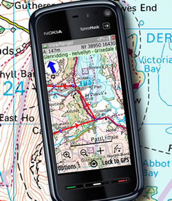
The software makes it easy to download a variety of maps. Originally, I thought I would use Ordnance Survey maps and I bought some map credits that would allow me to download OS map ’tiles’ on demand. It costs £1 per tile. However, I discovered that Open Street Map and, in particular, Open Cycle Map, give me most of what I need. Open Cycle Map has footpaths and bridleways marked and whilst it does not give the incredibly detailed mapping of Ordnance Survey, it does the job pretty well (in most cases). I found an instance on a recent trip where Open Cycle Map seemed to be missing the data for that specific location but otherwise it’s been fine. Of course, if you are mountain biking in rather more extreme locations than me and/or need more detailed maps, go for OS maps (in the UK at least).
Tracking a Route
Using its Record Track function, ViewRanger will keep track of where you are and show where you have been on the map of your choice. It has worked really well for me so far. The route points are close together and it’s very accurate. It’s great if you are in an area that you don’t know very well. The software stores a log/summary of the track as well (with average speed, distance etc). The tracks can be viewed again or exported – or deleted.
Using ViewRanger with maps that are not available for download, in particular Google Maps, requires that you upload your route to a web application or export/import the route data GPX file into Google Maps. This may not be that easy for everybody but I found it reasonably easy to use the Data Manager in ViewRanger to export the data file to my PC. I imported into Google Maps manually but mostly I’ve been using another web application that does this automatically as you ride.
Beacons and Uploading Routes
In order to upload the route as you ride, I’ve used the beacon function of ViewRanger. This sends a beacon or location point at specific time intervals until you turn it off. It sends the location using ViewRanger’s Buddy Beacon system and other web applications (like this one) can connect to this to display your maps. The Buddy Beacon system can also be used if you are on a group ride to show other riders where you are and beacons can also be viewed on the ViewRanger website.
- Tip: You need to login to your ViewRanger account on the website and switch on “Record Beacon Track” before beacon sending will work.
- Tip: Ensure you have also switched on “Send Old Positions” on your phone (in ViewRanger settings) because this means that ViewRanger will keep track of old beacons if there is no mobile internet connection. All unsent beacons will be sent when the connection is re-established.
One thing I’ve found when using ViewRanger beacons during cycle rides is that the beacon Update Frequency needs to be set quite low (less than a minute). The default is 5 or 10 minutes and this is too long for cycling. You can cycle quite a distance in 5 minutes so a long interval between beacons means that the route is less accurate. So, change the Update Frequency to half a minute or so and you should be ready to go!
- Tip: This may only apply to my Nokia but I found that the phone sometimes turned off ViewRanger if it was running in the background. Not so useful! However, in the ViewRanger UI settings menu, turning on “Ignore System Exit” seemed to prevent this.
Summary
Overall, I think that ViewRanger GPS is excellent and I’ve found that downloading maps, tracking my route, and using the Buddy Beacon system is pretty straightforward.
I’m planning to use ViewRanger and the Buddy Beacon system on an upcoming group cycle ride (this one, Cycling In Kent) where I will be doing more with it, for example sending photos and other information during the ride. No doubt there will be a few occasions when I’ll be using ViewRanger to find my position when I’m lost as well!


Clive
Nice article by the way. I’ve just sorted the Viewranger app onto my Nokia 5800 and am looking on how best to use it. I have no experience yet so your article has been most useful.
Your comment under the tracking and route section states: I imported into Google Maps manually but mostly I’ve been using another web application that does this automatically as you ride.
Which web app do you use?
About the Beacon. What time do you have for your update frequency when using the beacon? If my Dad was to log an account on Viewranger could he add me as a friend and then view my ‘live’ rides from the web?
You say: You need to login to your ViewRanger account on the website and switch on “Record Beacon Track†before beacon sending will work.
I can’t see in my account pages where to turn on the beacon. Can you let me know how to get to this page?
Cheers
Hi Steve,
I have been using Social Hiking as the web application. It’s in development at the moment but I’m one of the early test users. Contact Phil via the Social Hiking website and he will let you know the current status and if accepting new test users.
The Social Hiking app will let your Dad view your live position on a map, and it will also let him see photos and other information eg Twitter comments that you upload, but you can also use the ViewRanger Buddy Beacon page to view positions. No account required but your Dad will need to enter your username and beacon pin number (this number is set by you on your phone).
For set-up of Record Beacon Track, login to the ViewRanger portal for this.
For Update Frequency, I use 0.5 minutes for cycling.